An ancillary data set was collected in conjunction with reflectance measurements to describe the soybean field by its canopy geometry, ground cover, biomass, leaf area index and development stage. These data sets satisfy the input requirements for testing the validity of most mathematical models of canopy reflectance.
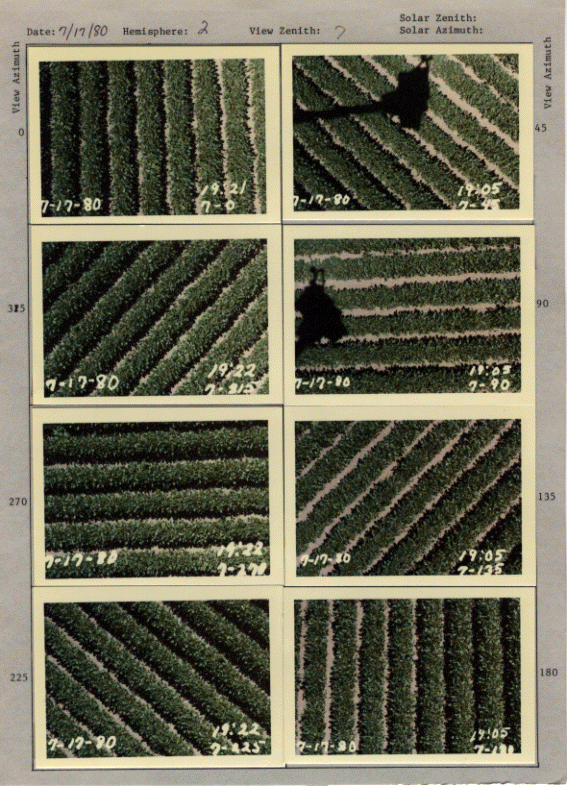
Photographs were also obtained to coincide with each spectral observation. Example page of photographs; this image was scanned in 1994:
Note that the hand written numbers written vertically next to some of the photos in the pdfs below represent the observation number for the respective reflectance data. The image sets below were scanned in May 2021. Photos for data set collected on 7/17/1980 (23 MB) Photos for data set collected on 7/24/1980 (27 MB) Photos for data set collected on 8/27/1980 (66 MB)
The development stages of the soybeans for the three dates spectral data were collected are:
                 Development      Ground      Plant
      Date          Stage         Cover       Height
                                   (%)         (m)

     7/17/80        V13R3          72           .69
     7/24/80        V14R3          83           .89
     8/27/80        V20R6          99          1.02
Also canopy geometry measurements were collected for 25 cm. of row at 2 locations in each field for each date. The geometry measurements included:
LARSPEC Identification Record Codes
1. Scene Type
The pair of numbers after 'SOYBEANS' or 'BARE SOIL' indicate the nominal view zenith and azimuth directions - zenith first, azimuth last. Nominal refers to the angles marked on the platform that were used for reference during data acquisition. The actual view zenith angle and azimuth angle are stored in the LARSPEC identification records under view zenith angle (VIZE) and view azimuth angle (VIAZ), respectively. The actual view zenith angle differs from the nominal view zenith angle for the first two days because the platform on which the Exotech 100 was rotated was not level. Therefore the view zenith angle changed for different view azimuth angles. On the third date of data collection a new mounting apparatus was used which made it possible to level the platform. Therefore the nominal view zenith angle and actual view zenith angle are the same for the third day.
2. Irradiance Azimuth Angle
This angle represents the direction of the solar disc measured clockwise from North. In other words it is the azimuthal angle from which the directional solar rays are coming.
3. Irradiance Zenith Angle
This angle represents the direction of the solar disc measured from a vertical line passing through the earth at the soybean field.
4. View Azimuth Angle
This angle represents the direction that the Exotech 100 Landsat band radiometer is viewing towards measured clockwise from North.
5. View Zenith Angle This angle represents the direction that the Exotech 100 Landsat band radiomenter is viewing measured from a vertical line passing through the earth at the soybean field. The view zenith angle is stored as a 2-digit value not has a 3-digit value as indicated by the data format description in the R1 line of data.
1. Ranson, K.J., V.C. Vanderbilt, L.L. Biehl, B.F. Robinson, M.E.Bauer, 1981, Soybean Canopy Reflectance as a Function of View and Illumination Geometry. Proceedings 15th International Symposium on Remote Sensing of the Environment, Ann Arbor, MI, May 11-15, pp. 853-856.
2. Ranson, K.J., L.L. Biehl, C.S.T. Daughtry, 1984, Soybean Canopy Reflectance Modeling Data Sets, Technical Report No. 071584, Laboratory for Applications of Remote Sensing, Purdue University, West Lafayette, IN, 25pp.
3. Ranson, K.J., L.L. Biehl, M.E. Bauer, 1985, Variation in Spectral Response of Soybeans with Respect to Illumination, View and Canopy Geometry, International Journal Remote Sensing, Vol. 6, No. 12, pp. 1827-1842.